Ground Penetrating Radar in Response
to Hazard
Hager-Richter GeoScience performing the GPR survey for VTrans
Ground Penetrating Radar (GPR) is a geophysical method that uses radar pulses to provide high-resolution images of the subsurface in a short amount of time. Though it is not one of the highlighted Advanced Geotechnical Methods in Exploration (A-GaME) techniques, GPR can be a valuable and versatile subsurface exploration tool.
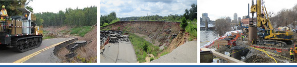
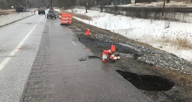
Recently Vermont Agency of Transportation (VTrans) used GPR to identify the size and extent of apparent voids caused by a failing metal pipe culvert located beneath the heavily travelled Interstate I-89 and an adjacent town road. The top of the culvert ranged from approximately 18 to 25 feet below the pavement surface. Several voids had developed at the ground surface located within the medians and directly adjacent to the pavement, and dipping and cracking of the pavement within the travel lane and shoulder of the roadway were noted, causing one travel lane to be closed.
Along with visual and survey monitoring of the roadway, borings were performed by VTrans and GPR surveying was performed to supplement the findings from the borings. The subsurface information was used to identify the extent and depth of the voids and areas of disturbed soils between the pavement and the culvert structure within the travel lane and shoulder of I-89 NB, and to confirm that the passing lane could be left open to traffic. While the team considered plans to develop a longer-term solution over the next few weeks, an additional GPR survey was performed. A comparison between the two surveys was performed to track progression of the voids in terms of depth, overall size, and lateral extent and to assess the potential for possible migration of the voids to the adjacent open travel lane. Both the GPR and the boring information helped to develop profiles of the soils and identify a ground improvement alternative that would work in conjunction with the lining of the large culvert, as well as to identify specific areas and depths to target in when filling the voids from the surface. As a result of the information from the GPR, VTrans opted to use a culvert liner and compaction grouting to successfully stabilize the subsurface voids and sinkholes.
“GPR was quite a significant tool for us in the beginning to help understand the situation and our comfort level, and to inform decisions going forward,” explains Callie Ewald, P.E., geotechnical engineering manager at VTrans. “Being able to do a baseline GPR survey and then survey again a couple weeks later provided us with valuable information on the rate at which soils may be migrating as water continued to infiltrate through the culvert, piping soil fines away.”
Overall, the VTrans project is a perfect example of using proven, effective site characterization – such as GPR – for identifying geotechnical hazards.
Voids along I-89 in Vermont
Unmanned Aerial Systems for Site Characterization
A recent Public Roads article, Looking to the Sky for Geotechnical Data, highlights the use of unmanned aerial systems (UAS) as a valuable tool in the geotechnical toolbox for site characterization. Benefits include fast response to emergency events, decreased data acquisition time, reduced cost, greater operational efficiency, improved quality, and significantly improved safety at hazardous or unstable sites. Transportation agencies’ use of UAS has increased significantly in the past few years, and many State DOTs have created new programs related to UAS applications. The photos, videos and 3D measurements obtained from UAS are already improving standards of practice for geohazard visualization, change detection, risk assessment, informed decision making and hazard/asset management.
Read the article
|
A-GaME Webinar #2 focuses on selecting the right site investigation tools
A-GaME Webinar #2 - Selecting the Right Tools for the Job
Webinar #2 in the series on the A-GaME (Advanced Geotechnical Methods in Exploration) kicks off with Jerry DiMaggio of Applied Research Associates and Erik Loehr of the University of Missouri discussing selecting the right site investigation tools for the job and establishing project goals. The two presentations are followed by a panel discussion with John Pilipchuk (NCDOT), Krystle Pelham (NHDOT), Bill Owen (CalTrans), Marc Fish (WSDOT) and Richard Lamb (MnDOT). The panelists address a number of questions including, How do you judge how much site investigation to do on project? When do you use a multi-phase investigation? When do you use contractors for site investigation versus your in-house team? The discussion ends with the panelists offering advice to organizations that see the value of A-GaME technologies, but are in the early phases of integrating them routinely.
Watch the video.

A-Game Webinars
Deep Foundations Institute (DFI) is hosting and distributing recordings of the 2020-2021 winter webinar series, featuring the FHWA A-GaME on its YouTube Channel.
The webinars feature a variety of topics related to proven, effective exploration methods and practices for enhanced, effective site characterization that reduce project risks, improve quality and accelerate project delivery.
|
Stay Connected |
|
 |
If you are not already a subscriber, the Center for Accelerating Innovation invites you to subscribe to EDC News and Innovator. These newsletters showcase successful deployments of EDC initiatives and other innovative topics in the highway industry.
|