|
Yesterday, our Board of Supervisors held a special meeting to approve sending a letter to President Biden. The subject matter was about how to provide help to those who suffered losses during the Caldor Fire. We requested funds from FEMA (the Federal Emergency Management Agency) for public assistance and although FEMA approved assistance to public agencies, their approval is still needed for private homeowners. At this time that request, called Individual Assistance, is still being considered by FEMA. This has created ongoing uncertainty and additional hardship for individuals and families impacted by the Caldor Fire.
Many people were uninsured, and most are underinsured. Ultimately, many of them face overwhelming challenges in their recovery. Costs to rebuild in northern California are at an all-time high due to COVID-19 supply chain issues, labor shortages and a severe shortage of housing.
Based on this information, if Individual Assistance is not provided, it will create significant and long lasting impacts to El Dorado County residents. Federal assistance is desperately needed to support survivors in their recovery and to ensure our County endures beyond the catastrophic Caldor Fire.
While touring the Caldor Fire recently, President Biden gave El Dorado County a verbal commitment to assist individuals impacted by the fire. Although FEMA has yet to send the funding mechanism to the President’s desk to sign, staff believes a letter to the President is appropriate at this time. View the final draft of the letter here. I am hopeful that our actions will spur funding to proceed quickly so that our residents can begin the long process of rebuilding and getting on with their lives.
A note to those who have cabins on USFS land that was damaged or destroyed… Our staff is working with the USFS and CalOES to try to address your needs. It is particularly difficult due to the complexity of working with various agencies, but we are trying to get you help and answer your questions as quickly as possible.
The El Dorado County Health and Human Services Agency, Public Health Division, is conducting low-cost community flu vaccination clinics until November 6, 2021. Seasonal influenza vaccine will be available in flu shot form at the clinics; a limited supply of FluMist® will be available for children.
The best protection against the flu for residents 6 months of age or older is the flu vaccine. It is especially important to vaccinate high-risk people, such as children under age five, people 65 years and older, pregnant women and people with chronic diseases like asthma, diabetes or heart and lung disease. It’s also critical for health care workers and people taking care of high-risk persons to be immunized. Flu vaccination will be even more important this year during the COVID-19 pandemic.
The cost per vaccine is $10, but no one will be denied service due to inability to pay; cash or check is accepted. Parents should bring their child’s immunization records. Face coverings and physical distancing are required at all clinic locations. Updated information on flu clinics are posted to www.edcgov.us/publichealth and on the County Flu Hotline at (530) 621-6188.
West Slope Community Flu Clinic Dates and Locations for 2021:
- September 30, from 2:30 p.m. to 4:30 p.m. at Rolling Hills Middle School, 7141 Silva Valley Parkway, El Dorado Hills
- October 7, from 2:30 p.m. to 4:30 p.m. at Camerado Springs Middle School, 2480 Merrychase Drive, Cameron Park.
- October 21, from 10:00 a.m. to 12:00 p.m. at Pioneer Park, 6740 Fairplay Road, Somerset.
- October 28, from 10:00 a.m. to 12:00 p.m. at Diamond Springs Fire Station 49, 501 Main Street,
in the Conference Room, Diamond Springs.
- November 4, from 10:00 a.m. to 12:00 p.m. at El Dorado Hills Fire Station 85, 1050 Wilson
Boulevard, in the Conference Room, El Dorado Hills.
- November 6, from 10:00 a.m. to 1:00 p.m. at Divide Wellness Center, 6065 Highway 193, Georgetown.
South Lake Tahoe Community Flu Clinic Dates and Locations for 2021:
- September 30 & October 14, from 11:00 a.m. to 1:00 p.m. at the Senior Center, 3050 Lake Tahoe Boulevard, South Lake Tahoe.
- October 7, from 4:00 p.m. to 6:00 p.m. at Bijou School, 3501 Spruce Avenue, South Lake Tahoe.
- October 14, from 4:00 p.m. to 6:00 p.m. at Tahoe Valley Elementary School, 943 Tahoe Island Drive, in the Multipurpose Room, South Lake Tahoe.
- October 21, from 4:00 p.m. to 6:00 p.m. at Bijou School, 3505 Spruce Avenue, South Lake Tahoe.
Looking for a job? The Elevate to El Dorado Virtual Job Fair will be held on Thursday, October 21, 2021, from 9:00 a.m. to 1:00 p.m. The new event is free and open to anyone. To register visit: https://tinyurl.com/4xvx3925. The event is hosted by the El Dorado County Chamber of Commerce, El Dorado County Economic Development, El Dorado County Employment Resource Center and Golden Sierra Job Training Agency.
The virtual job fair will be accessible from any computer, tablet or smartphone. Job seekers will have the opportunity to connect with employers actively recruiting to fill open positions, submit resumes, participate in a live pre-screening video interviews, or schedule an interview for a future date. This event includes employers from industries such as manufacturing, healthcare, technology, civil service, hospitality, retail, education and agriculture.
For more information about the virtual job fair, please contact jobs@goldensierra.com or call (916) 746-7722.
The virtual job fair is offered as a community service in partnership with the El Dorado County Employment Resource Center. The El Dorado County Employment Resource Center is a program of the El Dorado County Health and Human Services Agency. El Dorado County Employment Resource Center assists El Dorado County residents with job searches, job skills training and workshops, resume development, work experience and more. For information about these and other free job assistance services in El Dorado County, please call (530) 642-4850 in Placerville, or (530) 573-4330 in South Lake Tahoe, or visit www.edcgov.us/humanservices.
The County of El Dorado's Department of Transportation is requesting bids for snow removal on several bike paths in the South Lake Tahoe area. Click here for information and required documents that define the scope of services and outline the requirements that must be met by Proposers interested in providing such services.
A pre-bid meeting is scheduled for this contract on Thursday, October 7th, 2021 at 2:00 p.m. via Zoom. The meeting information is as follows:
Meeting ID: 894 2824 8698 (346) 248 7799 US (Houston); (720) 707 2699 US (Denver); (253) 215 8782 US (Tacoma).
In the spirit of staying connected, we wanted to share a couple of updates from Sierra. It’s been a busy week of inspections on the mountain, and we hope to have details to share soon. Several agencies (Forest Service, PG&E, etc.) have been hard at work to restore power to the area, clear trees, monitor active burns and clean up from the Caldor fire. We do want to remind everyone that the resort is still in the mandatory evacuation (red) status so we have a very limited crew of people that can come on site.
Many of you have reached out asking how you can help, and we are so appreciative for the love & support. This is what makes Sierra such a special place to us all. Thank you from the bottom of our hearts!
Below are a couple of opportunities you may want to consider:
-
The Sierra Education Foundation have organized a fund to assist our employees who lost tools, equipment, etc. in the fire. If you would like to donate, please check out the GoFundMe page: https://gofund.me/6856f9fb
-
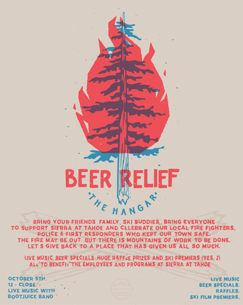
The Hangar is also holding a benefit event on October 9th from 12 noon to close and plan to have 2 movie premiers, tons of raffles, and one of our favorite bands: Boot Juice!! Come hang out, see some friends, share some stories, and enjoy fabulous food & drinks.
The Department of Insurance has several tools on their website to help you search the marketplace for residential insurance.
Top Ten Tips for Finding Residential Insurance provides a summary of the information and options available: http://www.insurance.ca.gov/01-consumers/105-type/5-residential/Top10Tips_FindingResidentialIns.cfm
The Home Insurance Finder tool can help you identify insurance companies and licensed agents/brokers who have been identified to sell homeowners, renters, condominium, or mobile home insurance: https://interactive.web.insurance.ca.gov/apex_extprd/f?p=400:50
The Residential Insurance Company Contact List provides toll free numbers for over 50 insurers that are licensed to sell homeowners insurance. You can contact each of them to find the closest agent or broker or, in some cases, get a quote from them directly: http://www.insurance.ca.gov/01-consumers/105-type/95-guides/03-res/res-co-contact.cfm
If you have questions about your home, auto, business, life or other insurance contact the Department of Insurance at 800-927-4357 or visit at http://www.insurance.ca.gov/
Wildfire Response and Readiness: http://www.insurance.ca.gov/01-consumers/200-wrr/
Residents whose homes have been damaged or destroyed by the Caldor Fire and are interested in the State’s free hazardous debris removal program must complete a Right of Entry Permit (ROE) to allow their property to be cleaned up, free of charge regardless of insurance status. Please complete the paperwork entirely to avoid delays. The California Office of Emergency Services (CalOES) has set a deadline for submittal of your ROE to the County by 11/15/21 @ 5:00 PM. The more residents who submit an ROE, the faster the County will get the assistance!
 |
|
Homeowner's Guide to Fire Recovery
October 6, 2021
5:30 p.m. – 8:00 p.m.
Click to Register
|
This is a free class from the UC Master Gardeners, Resource Conservation District and CA Native Plant Society.
CURRENT SITUATION
The Caldor Fire began on August 14, 2021, at 6:54PM four miles south of the Grizzly Flats community. The cause of the fire is currently under investigation. The fire is currently 221,775 acres and is 91% contained. 782 structures have been destroyed, 1,353 structures are currently threatened, and 81 structures are damaged. There are currently 1,467 personnel and 10 helicopters assigned to the incident. Full containment is expected for October 16, 2021. Sunday at 5:00pm will be the next Community Facebook live meeting and there will be one Daily Update per day, unless conditions change.
Warm, dry air and light winds will continue over the fire for the next couple of days with temperatures possibly reaching into the low 80s. As a result of the higher temperatures and lower humidities expect increased fire activity and smoke, mostly within the interior. Fire personnel continue to respond to and eliminate persistent smokes. Due to PGE crews working to restore power, expect intermittent road closures along Hwy. 50
USDA FOREST SERVICE – FOREST CLOSURE INFORMATION
-
ELDORADO NATIONAL FOREST:
-
The forest-wide closure has been replaced with the Caldor Fire Closure. All roads, trails (including the Mormon Emigrant Trail) and facilities within the fire closure area are closed. For more information: Forest Order 03-21-18 and Eldorado NF Closure Information.
-
Expanded Fire Restrictions & Camping Restrictions: ALL fires are prohibited on the forest, including gas and propane. For more information: Forest Order 03-21-16. Overnight camping is temporarily prohibited in the forest. For more information: Forest Order 03-21-17.
BURNED AREA EMERGENCY RESPONSE TEAM (BAER): A BAER team continues work in the Caldor Fire area. A rapid assessment of burned watersheds is being conducted to identify imminent post-wildfire threats to human life and safety, property and critical natural or cultural resources on National Forest System lands and to take immediate actions to implement emergency stabilization measures before the first post-fire damaging event.
See Caldor Post Fire BAER Inciweb site: https://inciweb.nwcg.gov/incident/7842/
 |
|
Evacuation Warnings Rescinded |
This important message is from the EDC Sheriff's office:
Evacuation Warnings due to wildfire have been rescinded for the Desolation Wilderness area north of Pyramid Peak, residences accessed by the US-50 Corridor between Sierra-At-Tahoe to Meyers, and the Christmas Valley area described as the SR-89 corridor between Meyers and SR-88.
Note that the National Forest is still closed by Forest Order. There still may be equipment moving in the area, please drive safely.
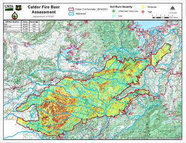
USDA Forest Service Burned Area Emergency Response Team (BAER) specialists recently completed their data gathering and analysis of the Caldor burned area to produce a Soil Burn Severity (SBS) map of the 218,952-acre fire.
LINK TO ARTICLE: Caldor Post-Fire BAER Soil Burn Severity Map Released - InciWeb the Incident Information System (nwcg.gov)
LINK TO JPG & PDF MAPS: Caldor Post-Fire BAER Maps - InciWeb the Incident Information System (nwcg.gov)
USDA Forest Service Burned Area Emergency Response assessment teams are multi-disciplinary teams sent to federal lands following significant wildfires to characterize the fire effects to watersheds, identify imminent post-fire threats to human life and safety, property, infrastructure, and critical natural and cultural resources. Once the assessment is complete, the team develops BAER emergency treatment recommendations to mitigate identified risks. BAER implementation teams are then brought in after the assessment to implement its recommended treatments and action stabilization measures. These teams begin their assessment immediately after the fire threat passes. The team focuses on the direct damage caused by the fire, rather than from fire suppression activities. Post-fire conditions such as loss of vegetation and the changes in the soils will increase the likelihood of floods and may cause potential debris and sediment flow impact.
For complex fires such as the Caldor Fire, assessments are done as an inter-agency effort which includes a California State Watershed Emergency Response Team (WERT) (Watershed Emergency Response Team (acwi.gov). The CalFire WERT assessment team is currently evaluating burned private and state lands from the Caldor Fire. Both assessment teams share information and data as they complete their burned area evaluations, analysis and subsequent reports. The teams also collaborate with other agency, utility and private entities.
BAER specialists recently completed their data gathering and analysis of the Caldor burned area to produce a Soil Burn Severity (SBS) map of the 218,952-acre fire. The map and the data display SBS categories of burn severity to include Unburned/Very Low, Low, Moderate, and High. Approximately 47% of the 218,952 acres are either Unburned/Very Low and/or Low SBS, while 40% sustained a Moderate SBS, and about 13% High SBS.
It is important to note that the BAER team assesses the effects to soils and not the effects to vegetation. Soil burn severity characterizes the effects at the soil surface and below-ground whereas vegetation effects are determined based on mortality and vegetation canopy changes. Forest Service silviculture and ecology specialists will be assessing the effects of the fire on the vegetation burned by the Caldor Fire.
Changes in soil cover, water repellency, and soil physical/biological changes determine the severity level of soil burn severity. Changes in water repellency is a much-discussed fire effect. Water repellency is a natural soil property. Fire can increase the severity and the thickness of the water repellent soil which has significant effects to post-fire water runoff.
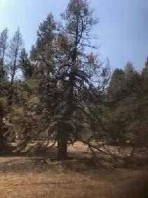
Low SBS indicates there was only partial consumption of fine fuels while litter coverage remains relatively intact on the soil surface. Burning time at the soil surface was short, leaving root systems and root structure undamaged. Vegetative recovery time in the low category will vary based on ecological community but is expected to recover in the short-term.
Moderate SBS indicates nearly all soil cover of vegetative litter and fine fuels was consumed or converted to ash. Because soil cover is significantly reduced, accelerated water runoff is expected. Charring of the mineral soil occurs in Moderate SBS as well as shallow root burning. The extent of the burning of the leaves and needles on the trees (aka tree canopy) can be unpredictable and can range from high to relatively low mortality. Water repellency is often found at the surface and is increased for both in severity and thickness of the water repellent soils which reduces the ability of precipitation to infiltrate the soil surface.
High SBS is the result of higher intensity fire behavior or longer burning time at the soil surface. As a result of the high heat, nearly all the soil cover of vegetative litter and fuels has been consumed leaving bare soil prone to the impacts of precipitation and resulting water runoff. The surface mineral soil has been reduced to powder (single grain) and often several inches thick. This single grain soil is very easy transported or moved during rain events resulting in excessive soil erosion and sediment loading in rivers, streams, and creeks. The roots in the High SBS areas tend to be completely consumed by the resulting heat of the fire above the soil surface. Water repellency does not exist at the surface because water repellent compounds have been vaporized and tends to be found below the powdered soil surface, but the repellency thickness and more severe burning tend to be much greater than a Moderate SBS soil. Generally, there is 100% tree mortality in High SBS soils. Fire-adapted shrubs and vegetation such as bear clover, manzanita, and deer brush tend to come back with vigor because of root sprout; however, because seed sources are consumed in these High SBS areas, conifers may take many years to re-establish without tree planting.
The Caldor BAER assessment team used initial remote sensing imagery with its field validated soils data, to develop and produce the final SBS map. The BAER team and the US Geological Survey (USGS) both use the SBS maps as an analysis tool to estimate post-fire flows, debris flow probability, erosion and sedimentation flow rates.
The Caldor Fire soil burn severity map can be downloaded at the “Caldor Post-Fire BAER” InciWeb site (https://inciweb.nwcg.gov/incident/7842/) as a JPEG or PDF version under the “Maps” tab.
SPECIAL NOTE: Everyone near and downstream from the burned areas should remain alert and stay updated on weather conditions that may result in heavy rains over the burn scars. Flash flooding may occur quickly during heavy rain events-be prepared to take action. Current weather and emergency notifications can be found at the National Weather Service website: www.weather.gov/sto/.
|