Skip to Main Content

MyCoast Data Shows Impact of January Flooding

Community reports in MyCoast app reveal extent of flooding across the state
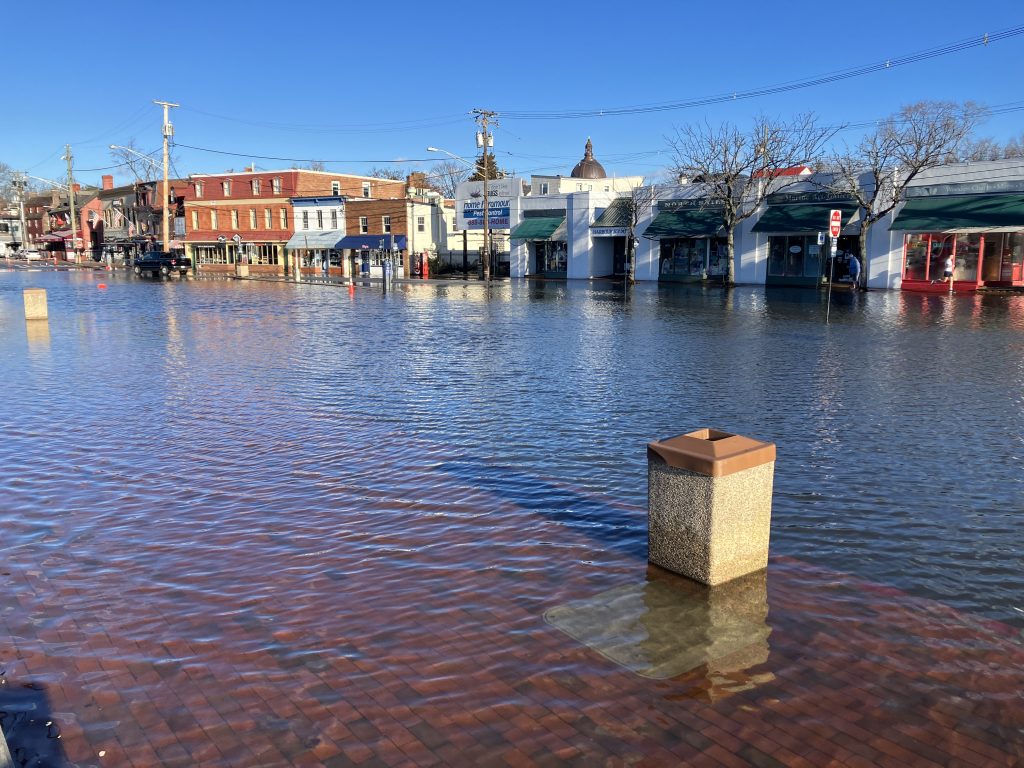
An Annapolis street covered in water from flooding.

Flooding in Annapolis on Jan. 9. Photo submitted to MyCoast, Maryland Department of Natural Resources.

On Jan. 9, Maryland was hit by a storm that brought intense rain, strong winds and high tides.

It resulted in the most active week yet for the Maryland Department of Natural Resources’ MyCoast MD app. The app allows users to submit reports and photos of flooding, as well as other environmental information. The storm brought in about 400 new users for MyCoast, along with 248 reports of flooding.

Reports came largely from the counties along the Chesapeake Bay, with 77 reports from Anne Arundel County, 36 from Calvert County, and 33 from Somerset County. Most reports indicated high tide flooding, though others reported storms or coastal damage.

The flooding broke multiple records. National Oceanic and Atmospheric Administration tide gauges recorded the highest ever crests in Havre de Grace since the gauge was installed in 2012, as well as crests that reached the top five in Baltimore, Solomon’s Island and Chesapeake City. Annapolis saw a high tide of 5 feet, one of the highest on record for the city. The coastal zone of Maryland was under a flood warning for multiple days.

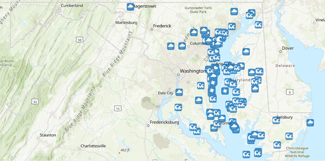
Map of Maryland showing flooding reports

MyCoast reports received in January 2024

The storm dropped more than 2 inches of rain in some areas of the state–a considerable total when most counties see an average of about 3 inches of rain during the entire month of January.

With these conditions, municipalities benefit from receiving as much information as possible about flooding and areas of concern. Officials have pointed to MyCoast as a tool that can fill in the blanks for flood response, showing how and where infrastructure is affected by flooding.


Click the buttons above to download the MyCoast.org app on your iPhone or Android device.

Flood planners and emergency managers are able to access MyCoast data, which can be sorted by municipality or county and can supplement information reported to 311 and 911 systems. A real-time data layer shows MyCoast reports as they come in, plotted on a map.

MyCoast has become an important tool for communicating the extent and impacts of flooding–something that is only possible because of its community users. The January flooding brought in many new users, which will help officials understand and plan for  future storms.
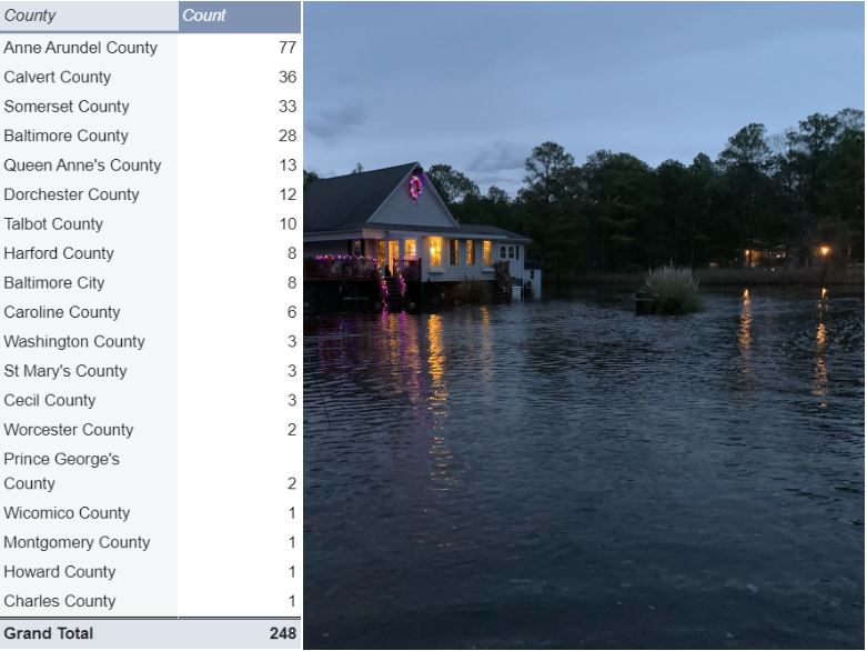
Table showing MyCoast flooding reports by county, next to an image of flooding by a home in Dorchester County

MyCoast reports by county. Right: Flooding near a home in Susquehanna Point in Dorchester County. MyCoast-submitted photo

Article by Kate Vogel, coastal resilience planner with the Maryland Department of Natural Resources.

doit-ewspw-W02
Close window
Close Disclaimer

Google Translate Disclaimer

The Maryland Department of Information Technology (“DoIT”) offers translations of the content through Google Translate. Because Google Translate is an external website, DoIT does not control the quality or accuracy of translated content. All DoIT content is filtered through Google Translate which may result in unexpected and unpredictable degradation of portions of text, images and the general appearance on translated pages. Google Translate may maintain unique privacy and use policies. These policies are not controlled by DoIT and are not associated with DoIT’s privacy and use policies. After selecting a translation option, users will be notified that they are leaving DoIT’s website. Users should consult the original English content on DoIT’s website if there are any questions about the translated content.

DoIT uses Google Translate to provide language translations of its content. Google Translate is a free, automated service that relies on data and technology ​​​to provide its translations. The Google Translate feature is provided for informational purposes only. Translations cannot be guaranteed as exact or without the inclusion of incorrect or inappropriate language. Google Translate is a third-party service and site users will be leaving DoIT to utilize translated content. As such, DoIT does not guarantee and does not accept responsibility for, the accuracy, reliability, or performance of this service nor the limitations provided by this service, such as the inability to translate specific files like PDFs and graphics (e.g. .jpgs, .gifs, etc.).

DoIT provides Google Translate as an online tool for its users, but DoIT does not directly endorse the website or imply that it is the only solution available to users. All site visitors may choose to use alternate tools for their translation needs. Any individuals or parties that use DoIT content in translated form, whether by Google Translate or by any other translation services, do so at their own risk. DoIT is not liable for any loss or damages arising out of, or issues related to, the use of or reliance on translated content. DoIT assumes no liability for any site visitor’s activities in connection with use of the Google Translate functionality or content.

The Google Translate service is a means by which DoIT offers translations of content and is meant solely for the convenience of non-English speaking users of the website. The translated content is provided directly and dynamically by Google; DoIT has no direct control over the translated content as it appears using this tool. Therefore, in all contexts, the English content, as directly provided by DoIT is to be held authoritative.