Storm Alex to hit France with powerful winds and heavy rain
The fast-moving area of low pressure that will develop in the Atlantic Ocean through Thursday, October 1 has been named Alex by the French National Met Service – Meteo France. This is the first named storm of the 2020/21 European windstorm season (September 1, 2020 – August 31, 2021).
- The storm is expected to rapidly intensify into a very powerful cyclone before it hits western France Thursday night into Friday, bringing strong winds to northwest France, with violent Force 11 winds at sea, and heavy rain to northern Spain and much of France.
- Wind gusts in France are expected to hit 120 km/h (75 mph) inland and up to 140 km/h (87 mph) or more along the coast, mainly in Brittany or even in parts of Pays de la Loire.
- Heavy rainfall accumulations are expected in Brittany and strong waves on the Atlantic coast.
- Southern England is expected to be hit by strong winds and heavy rainfall early Friday, October 2.
According to Met Eireann meteorologist Gavin Gallagher, the system will deepen very rapidly, going from 1 003 hPa at 10:00 UTC on Thursday to 971 hPa at 00:00 UTC on Friday – that's a deepening of 32 hPa in 14 hours.
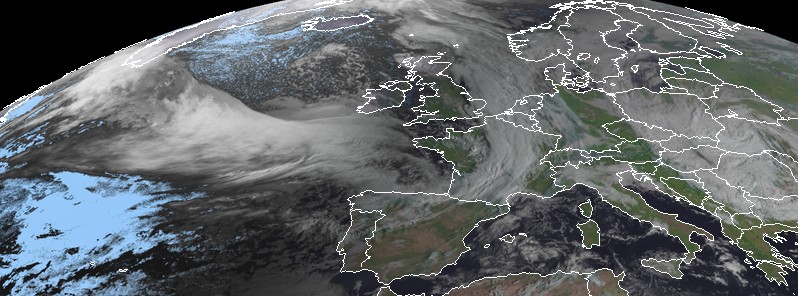
"At present (16:00 UTC, September 30) what will ultimately become Storm Alex is just a fairly innocuous surface trough out in the Atlantic – currently visible as a band of cloud. However tonight and early Thursday this will interact with a very strong jet stream in the upper troposphere which will rapidly deepen the surface trough into a very powerful cyclone."

Image credit: EUMETSAT/Meteosat-11. Acquired 07:50 UTC on October 1, 2020
Storm Alex will travel eastwards and strengthen through Thursday, entering the Bay of Biscay around 17:00 UTC, with winds impacting the west coast of France late Thursday evening, with the system crossing the French coast around midnight.
"This will bring very strong winds to northwest France on Thursday night with violent storm force 11 winds at sea," Gallagher said.
"Northern Spain will also experience strong winds on Thursday night, with strong winds impacting coastal parts of southern England from Friday morning."

Image credit: MeteoAlarm
The storm is part of a plunge of colder air pushing down over northwest Europe for the days ahead, with much of the associated precipitation over the Pyrenees and the Alps falling as snow, Gallagher added.
Ireland will also feel the effects of the storm with the broader area of low pressure associated with this weather event likely to bring heavy rain across the country later Saturday, October 3, and early Sunday, October 4 with a possibility of some flooding. Northerly winds will also strengthen over Ireland Saturday night and Sunday.

Image credit: MeteoFrance
MeteoFrance has placed 5 departments on an Orange alert and 28 on Yellow.
Alex will be a strong storm when it lands in Brittany in the middle of the next night in the departments placed on Orange alert, where gusts of the order of 100 to 120 km/h (60 – 75 mph) are expected inland and 120 to 140 km/h (75 – 87 mph) on the coast, or even more on exposed capes, MeteoFrance warns.
The storm will bring strong rains to Brittany, 40 to 60 mm (1.5 – 2.4 inches) in 24 hours generally, up to 80 mm (3.1 inches) or more locally, and 70 to 150 mm (2.7 – 5.9 inches) in 72 hours.
La perturbation associée à la #TempêteAlex va apporter des cumuls de pluie conséquents en Bretagne (40/80mm en 24h, et même 70/150 mm les prochaines 72h).
Grande prudence requise aussi demain sur les #AlpesMaritimes avec des pluies diluviennes en journée et soirée de demain ! pic.twitter.com/zFyiVJxVVT
— VigiMétéoFrance (@VigiMeteoFrance) October 1, 2020
Prévision confirmée. La #tempeteAlex apportera des vents violents la nuit prochaine, avec des rafales entre 100 et 120 km/h dans l'intérieur de la Bretagne, et entre 120 et 140 km/h sur le littoral (Morbihan, Loire-Atlantique), localement plus sur les caps exposés. pic.twitter.com/jvCXFAhjBo
— VigiMétéoFrance (@VigiMeteoFrance) October 1, 2020
#TempeteAlex : Rafales de vent tempétueuses attendues en milieu et fin de nuit de jeudi à vendredi (~130-140 km/h sur les côtes du #Morbihan et #LoireAtlantique voire plus sur îles/caps exposés) se propageant ensuite dans les terres en fin de nuit et matinée (100-120). #tempête pic.twitter.com/eUzjpkyaKK
— VigiMétéoFrance (@VigiMeteoFrance) September 30, 2020
Forecast models
Featured image credit: EUMETSAT/Meteosat-11. Acquired at 07:45 UTC on October 1, 2020
Commenting rules and guidelines
We value the thoughts and opinions of our readers and welcome healthy discussions on our website. In order to maintain a respectful and positive community, we ask that all commenters follow these rules.