SR 49 Confluence Study
If you would like to view this in another language, please activate Google Translate by clicking this icon![]() in the top right corner of your screen.
in the top right corner of your screen.
Si desea ver esto en español (u otro idioma), utilice Google Translate haciendo clic en este icono ![]() en la esquina superior derecha de la pantalla.
en la esquina superior derecha de la pantalla.
The SR 49 American River Confluence Study will examine infrastructure characteristics, corridor operations, and collision history to inform recommended improvements for parking access, new transit/shuttle services, safety, and operational efficiency. Recommendations may also include design elements that serve to calm traffic (i.e., reduce vehicle speeds) and improve visibility of pedestrians by motorists as well as rerouting of heavy-duty trucks.
To help inform the study recommendations, El Dorado County Transportation Commission (EDCTC) is soliciting public input through this interactive web-based mapping tool. Some of the key questions we would like to hear from the public on include, but are not limited to, the following:
- Where are good locations to provide formalized parking spaces on SR 49 within the study corridor?
- Where are good locations for shuttle stops on SR 49 within the study corridor?
- Where are locations that you feel are not safe or present safety issues?
- Where have you experienced issues with heavy-duty trucks on SR 49 within the study corridor?
- What is needed to make it easier or safer to cross SR 49 (as a Ped and/or Driver)?
- What is needed to make it easier or safer to cross SR 49 (as a Ped and/or Driver)?
- How/where would you support re-routing heavy-duty trucks?
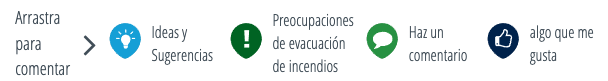
To leave your feedback drag one of these icons at the top of the page to a point in the map to leave a comment, suggestion or concern:
Be sure to zoom in on the map to precisely place your comments where your concern or interest is. You may also attach/upload images if you think it will help us better understand your perspective. All comments will remain anonymous but all comments will be made public once the comment period for this phase of outreach closes.
Para dejar sus comentarios arrastre uno de estos iconos en la parte superior de la página a un punto del mapa para dejar un comentario, sugerencia o preocupación:
Asegúrese de acercar el mapa para ubicar con precisión sus comentarios donde está su preocupación o interés. También puede adjuntar/cargar imágenes si cree que nos ayudará a comprender mejor su perspectiva. Todos los comentarios permanecerán anónimos, pero todos los comentarios se harán públicos una vez que se cierre el período de comentarios para esta fase de divulgación.