San Andreas Fault Tour near Wrightwood
We are going to take you on a tour of the San Andreas Fault, starting in the Cajon Pass, through Wrightwood and Big Pines, then along the north side of the San Gabriel Mountains. California is world-famous for many things and one of them is earthquakes. This introduction to a small section of the infamous San Andreas Fault will show you what the fault looks like and where to go see it.


California is covered with earthquake faults. Most people have heard of the dreaded San Andreas Fault yet many of the State’s greatest earthquakes did not happen along the San Andreas. Some of us living in Southern California have heard of other faults like the Helendale, San Jacinto and Elsinore faults but the San Andreas is different. It is a “plate boundary” where the Pacific and North American Plates meet and grind past each other. This grinding action has gone on for millions of years and is what causes earthquakes as well as the features you will see on our tour.
During the tour, keep in mind that the fault is just not a crack in the earth. It is more of a fault zone. This zone can be filled with multiple fractures. In some places, the zone can be just twenty feet wide and other places it can be almost a mile wide.
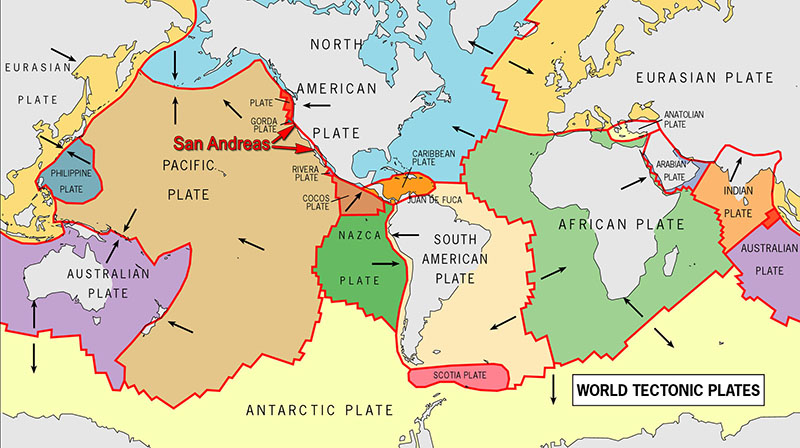
Tectonic Plates
Every geology lesson starts out with looking at a map of the World showing where all the tectonic plates are located. Our tour is no different. Many such lessons even start off with a map of the supercontinent Pangaea, but we’re not going to subject you to that. It is important to note however, that the San Andreas Fault is the division of one of those two huge tectonic plates mentioned earlier.
If you watch our YouTube virtual video tour below, you’ll see the map of the World’s tectonic plates. You’ll see that the next plate boundary to the east of the San Andreas is in the middle of the Atlantic Ocean where the North American Plate meets the Eurasian and African Plates. The next plate boundary to the west is on the other side of the Pacific Ocean. Think of that distance. During this trip, when you either drive or straddle over the fault line, we hope you feel how significant of a thing you’re passing over.
Below is that World map of tectonic plates.
The Tour Begins
We start our tour at the southern end of the Cajon Pass. Use a map or your GPS to get to the intersection of Cajon Blvd (Route 66) and Swarthout Canyon Rd. See our map below for more geographic detail. Reset your odometer to zero and head across Cajon Creek and the railroad tracks.
At 0.6 miles, you’ll come to the first San Andreas Fault feature – a sag pond. It’s located on the right side, on private property next to a residence, and is difficult to see from the road. On this tour, we are going to see a lot of sag ponds, which are all features created by the fault. A sag pond is formed when underground water seeping along the fault line comes to some sort of blockage, is forced up to the surface at a low spot along that blockage, creating a pond. This blockage is often a fine earth material, such as clay, that has been created by the fault’s grinding action. Watch the video to see a diagram.
At this same point but on the left side, you can see where the San Andreas caused some unique erosion on the hillside next to route 66. This is known as Blue Cut. It got its name when early Route 66 travelers noticed the bluish tint in the soil. This form of erosion is called fault gouge and sometimes known as fault flour. We’ll cover this in more detail at a later stop.
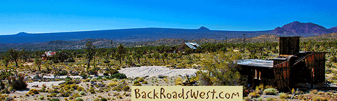
Lost Lake
Continue past the second railroad crossing and at 1.3 miles, you’ll reach the parking area for Lost Lake. This is another sag pond and one you can access. Walk the short distance here to take in the views of this unique body of water. Notice that the pond is long and skinny and that it is oriented in the same direction as Lone Pine Canyon, the long skinny valley you’ll soon be driving up. That orientation indicates the direction of the San Andreas Fault. This pond is right on top of the fault.
Driving on up the dirt road, you’ll pass by a few fault scarps that have been created by numerous earthquakes over the millions of years. A scarp is created in the few seconds during an earthquake when the earth is pushed up or moved sideways during the quake’s movement. This surface rupture looks like a small step or offset in the land and can be a few inches or many feet high. Unfortunately, most of the scarps along this trip are hidden by vegetation.
Lone Pine Canyon
Continue up the dirt road to a stop sign. Turn left onto the pavement of Lone Pine Canyon Road and notice how long and skinny Lone Pine Canyon is. This particular fault feature is known as a linear valley and there are many examples similar to this canyon all along the fault’s trace.
Clyde Ranch
Our next stop, which is 8.1 miles from route 66, is Clyde Ranch. This stop has nothing to do with the San Andreas fault, but has some nice history to it.
This ranch, built in the 1870s, was built by the Clyde family. It’s still owned by the same family today! And even more historically intriguing, is that the Clyde’s were good friends with the Earp brothers, especially Virgil and Wyatt. When Wyatt lived in San Bernardino, he would ride up here on horseback, following the same path you just drove, to visit his friends, the Clyde’s.
There is an old photogenic service station that sits along the road on this property. Remember however, that the building is on private property. If you dare to venture onto the property, just remember who the Clyde’s are friends with 😉
View Point
At about 10.7 miles, the road reaches a summit as it begins descending into another linear valley, which is where Wrightwood is located. Before you cross the summit however, find a safe place to pull over and look at the view behind you. You may have to walk along the guard rail a short distance.
On a clear day you can see the fault trace run from under your feet all the way to the mountains near Palm Springs, about 70 miles away. The large mountain in the distance on the left is San Gorgonio Mountain and the large mountain on the right is San Jacinto Peak. The San Andreas passes between the two. The three major mountain ranges you see here, the San Jacinto’s, the San Bernardino’s and the San Gabriel’s, the mountains you are in right now, were all created by the forces of the San Andreas Fault. The mountains were formed by compression and uplift caused by small bends in the fault. To learn more about this process, we recommend reading this article on Wikipedia.
Pictures
Below are some pictures of what you will see along the way.


Panoramic view of Lost Lake. Yellow shading marks approximate fault zone.
Shop for San Andreas Fault items
Scroll down to see and shop for items related to the San Andreas Fault from Amazon.
Books Recommended on Amazon
Virtual Video Tour
Wrightwood
Our next stop is another sag pond in the neighborhoods of Wrightwood. Following these driving directions:
- Continue straight on Lone Pine Canyon Road
- Turn right on Sheep Creek Road
- Turn left on Thrush Road
- Turn right on Oak Street
- Turn left on Twin Lakes Road
- Twin Lakes Road will turn right and the sag pond will be on the left
This sag pond is part of the Wrightwood Country Club. Like many other sag ponds on private property, this one was capitalized on. It is the Country Club’s one and a half acre swimming lake.
Drive around the lake to Cedar Street (turn left twice) to see another common characteristic of the fault. When you drive onto Cedar Street, this depression will be very obvious. In the trough of the depression, you’ll notice some water wells, which takes out water trapped by the fault, and feeds the local water supply.
When you’re ready to move on, drive down the hill on Cedar to Hwy 2. You’ll pass by the Wrightwood museum. One block to the left is Park Drive, which is Wrightwood’s main drag. Here, and on other streets, are several shops and dining choices if you’d like to take a break and catch a bite to eat. Jenson’s, on Hwy 2, is a unique market to check out and grab supplies for a picnic to eat later on this tour.
Big Pines
From Wrightwood, head uphill or west (left) on Hwy 2. You may not notice, but you’ll be driving up another linear valley, similar to Lone Pine Canyon. On the left, for the next few miles, there used to be other small sag ponds, but they have all dried up from increased water consumption for the residents of Wrightwood.
Soon, you’ll pass by the Mountain High east ski area. About a mile past the first ski area, look for a Visitor Center on the right. This is Big Pines. It was supposed to be the site of the 1932 Winter Olympics but so little snow fell that year, the Olympics were moved to Lake Placid, NY. The castle-like structure you see next to the Visitor Center is the remains of Davidson Arch, which was built in 1926.
The remains of the arch marks the highest point along the San Andreas Fault and behind the building is a scarp that marks the fault line paralleling Hwy 2. This scarp (including the other scarps mentioned so far) was most likely created during the huge 1857 Fort Tejon earthquake (see Wikipedia article) or the 1812 Wrightwood earthquake (see Wikipedia article).
Driving past the remains of Davidson Arch leads you into a confusing 5 point intersection. Make sure to reset your odometer to zero here. Take the second right, where signs point to Jackson Lake, which is Big Pines Highway and signed County Hwy N4.
Erosion
Drive past the Center and turn onto Big Pines Hwy, following the signs to Jackson Lake, and reset your odometer again. In about 0.6 miles, you’ll notice some oddly eroded embankments along the road on the right. At 0.8 miles, look for a safe place to pull over and park. You’ll see more erosion of this odd material if you walk across the street (lookout for traffic) and look over the edge. This odd erosion is everywhere. This material is known as fault gouge (sometimes also referred to as fault flour) and the deep gorge you see over the edge here is the fault zone.
Remember at the beginning of our trip, there was a feature called Blue Cut next to Route 66? The erosional feature you saw there is the same feature you see here.
Fault gouge is rock and dirt that has been pulverized into a fine powder from the grinding action of the fault. At this spot and others along the fault, such as Blue Cut, the two plates passing by each other created this fault gouge. It is very unstable and is easily eroded by water runoff.
Continue on down the road and at 2.0 miles, you’ll reach Appletree Campground. Here there is a dirt road on the left that heads back to that deep gorge you saw at the previously stop. You can walk up this road for a closer look at all the odd erosion and geological chaos that was created here by fault action.
Jackson Lake
A short distance past Appletree campground, you’ll reach Jackson Lake at 2.8 miles. Yup, you guessed it, this is another sag pond.
Similar to Lost Lake, this sag pond is long and skinny and oriented and pointing out the direction of the fault, paralleling the road.
Jackson Lake is popular with anglers and nature seekers alike. This is a great place to have a picnic with food that you may have picked up at Jenson’s or some other store in Wrightwood.
Unfortunately, in wintertime, Jackson Lake has been the place of tragedy for some people who were clueless about the dangers of walking on frozen lakes. Several people have died over the years playing on the not-so-thick ice of this innocent-looking sag pond.
Caldwell Lake
Just after an intersection where Hwy N4 goes to the right and our tour goes straight with Big Pines Hwy, you’ll see yet another sag pond on the left at 7 miles. This is Caldwell Lake and again it is long and skinny and oriented in the direction of the fault. This sag pond also is on private property, so enjoy the view from the road.
Past Caldwell Lake and at 10 miles, the road makes a u-turn to descend back into the fault zone. From the u-turn, it’s a great view of the fault zone as it passes through Valerymo. On a clear day, and with a keen eye, you can see the trace of the San Andreas through Palmdale and beyond for more than 50 miles.
Valerymo
Before you reach the small hamlet of Valerymo, you will see Big Rock Creek Road head off to the left (south). Here, Big Pines Hwy turns into Valerymo Rd. Just before the intersection at 11.4 miles, the fault crosses the road and passes over a ridge but is not very noticable. Just on the other side of the ridge is another sag pond on private property and not visible from the road.
Looking south down Big Rock Road and continuing past our tour is Devil’s Punchbowl. This rock group is similar to the large sandstone rock formations in the Cajon Pass near I-15 and Hwy 138, known as the Mormon Rocks. Supposedly, these two rock groups were once joined together. Over a few million years, the San Andreas chopped the rock group in half and has separated them this far apart. However, geologists debate whether or not these two rock groups are related. But geologically, it sounds logical that this could have happened.
The ranches and small post office of Valerymo are soon passed on the left. Behind the ranches are several fault scarps marked by increased vegetation. These again were most likely created during that big 1857 quake.
Pallett Creek Study Area
At 14.2 miles, turn left onto Fort Tejon Road and then a quick left onto Pallet Creek Road. Our final stop is at 15.5 miles. Park on the wide turnout on the left side of the road and watch out for oncoming traffic.
This is the spot where geologists decided to study a specific spot on the San Andreas. The spot was originally chosen because a long time ago it was s swampy area. During wetter years thousands to millions of years ago, damp peat moss formed and deposited and then dried up. This dried peat moss is very easy to radiocarbon date by scientists. Numerous fractures caused by earthquake events on the San Andreas are visible in the layers of dried peat moss. This gives the ability for geologists to date specific pieces of the peat moss to give an estimated year of when the event occurred. The offset in the peat moss also indicates the size (i.e. magnitude) of the event. Geologists were able to determine approximately when major quakes occurred on the San Andreas for the past 2000 years, including the 1857 and 1812 quakes, as well as a rough approximate frequency in years that quakes occur.
The study area has been worked for decades, beginning in 1978. When we visited in 2014, there was still a grid of kite string laying over the study area that was probably used for measurements. It consists of a single trench about 40 feet long perpendicular to the San Andreas, revealing the black peat moss layers. The trench used to be much larger around 1980. It became heavily eroded over the years and recently, around 2012, volunteers from the San Bernardino County Museum dug it back out.
Our trip ends here. If you have some extra time, continue on Pallet Creek Road, then left on Hwy N6, for a total of 5 miles, to the Devil’s Punchbowl overlook to get a good view of the rocks that may have originally been joined to similar rocks in the Cajon Pass.
Trip Map
Notice how the pins on the map literally plot the trace of the San Andreas Fault.
Support Us
Help us fill up our tank with gas for our next trip by donating $5 and we’ll bring you back more quality virtual tours of our trips!
Your credit card payment is safe and easy using PayPal. Click the [Donate] button to get started:
Subscribe
See all our comprehensive virtual tour guides at:
![]()