A259 Shoreham to Brighton & Hove boundary
Proposed cycling and walking improvements
This consultation ran from Monday 17th January to Monday 27th February 2023. The consultation report (opens in new window) has now been published. This scheme is being taken forward into the County Council capital programme for further design and outline business case development. A summary update about the next steps (opens in new window) for this scheme and the linked schemes in Lancing and Sompting that were consulted on at the same time is also available to view. The original consultation webpage text has been retained below.
West Sussex County Council is working to improve walking and cycling facilities across the County. By encouraging more walking and cycling, particularly for shorter journeys such as those to schools, we can help to reduce congestion on our already busy road network. We’ll also help to improve air quality and create safer, more pleasant places in which to live, work and do business.
Our West Sussex Transport Plan 2022 – 2036 (opens in new window) sets out how the county is intending to address a number of challenges, including climate change, congestion, and road safety. Adur District Council has also developed a Local Walking & Cycling Infrastructure Plan (opens in new window) that aims to improve the cycle network. To help address these issues, we are now consulting on feasibility designs for the A259 Shoreham towards Brighton cycle scheme developed through our Strategic Transport Investment Programme (STIP):
- A259 Shoreham to Brighton & Hove, from A259/East Street in the west to the County boundary in the east
We would like to hear your views on our designs for the A259 between Shoreham and the Brighton & Hove boundary by completing our survey (opens in new window). This survey is also available at the bottom of this webpage below the scheme summaries. The consultation is open until 11:59 p.m. on Monday 27 February 2023.
This scheme is not fully funded at this time, so your feedback will help us to shape further development of the designs and inform our decision on how to take the proposals forward, including helping to further build the case for these schemes. The scheme is expected to be funded using developer contributions and central Government grants that are intended for active travel schemes.
We are also consulting separately on feasibility design options for three cycle routes around Lancing & Sompting. If you would like to find out more about these routes, please visit our Lancing and Sompting page (opens in new window).
Scheme context
We commissioned the Shoreham Area Sustainable Transport Package to identify a package of transport improvements in the Shoreham area that will support growth in the local vicinity. This identified the potential for a cycle route along the A259 from Shoreham towards Brighton & Hove.
A two-phase approach is being adopted to the scheme:
- Phase 1 – initial engagement
- Phase 2 – formal consultation
We are now undertaking the phase 2 formal consultation.
The initial engagement period (opens in new window) was carried out from 8 March to 12 April 2022. During this first phase, the A259 Shoreham to Brighton scheme was presented alongside the B2144 Oving Road (Chichester) and Lancing & Sompting schemes. However, we are now taking forward formal consultation on the schemes individually.
The Early Engagement Summary Report provides the full analysis of the responses received during the engagement period, along with details on the promotional materials and stakeholders involved. In summary, the responses given to the A259 Shoreham to Brighton scheme showed:
- 79% of respondents supported the scheme to some degree
- 80% were in favour of improved crossings
- 70% supported a dedicated two-way space of cycling
- 70% favoured cyclist priority traffic signals
We have used all the feedback received to develop the design of the A259 Shoreham to Brighton & Hove scheme further for this consultation. Please review our information and plans before having your say via the survey at the bottom of this webpage.
About the proposals
The improvements along the A259 between Shoreham and Brighton & Hove would provide a safer, more desirable and direct route for the National Cycle Network route 2 (NCN2). The Shoreham Harbour area is part of a regeneration project that includes mixed use redevelopment on the Western Harbour Arm. It is therefore important to develop proposals for high quality cycle infrastructure that could serve these developments as well as the existing communities.
These proposals form part of a package of sustainable transport and road junction measures being developed around Adur District to mitigate the impacts of development and improve the transport network for local communities, including addressing congestion. Please refer to the accompanying summary document (opens in new window) and map of transport measures in Adur (opens in new window) which provides more information about how these cycle routes support the wider network measures.
This consultation covers proposals for the potential A259 cycle route to the boundary with Brighton & Hove. Brighton & Hove City Council is considering a connection along the A259 to the wider cycle network in the city as part of its Local Cycling and Walking Infrastructure Plan, where the A259 is a priority strategic route. In Adur District, the route would also help to improve the links to local destinations, including:
- Shoreham town centre
- Shoreham-by-Sea, Southwick and Fishersgate railway stations
- Retail and other local businesses
- Kingston Beach
- Shoreham Port
- Schools and colleges
The scheme could also connect to the Waterfront leisure path that has been proposed as part of Shoreham Western Harbour Arm development. This would provide a ‘shared use’ cyclist and pedestrian facility along the River Adur, acting as an alternative to the route along the A259.
By rerouting the NCN2 along the A259, the route would reduce in length by 25%. By making cycling between Shoreham and Brighton & Hove more direct, as well as providing a safe space for cycling off the road, it is expected that more people would be encouraged to cycle, particularly those less confident cyclists. This could reduce vehicle numbers, as people swap using their cars for active modes of travel. This would help to reduce congestion and improve air and noise pollution in the local area.
These improvements would be in addition to the potential schemes on the Middle Road and Upper Shoreham Road Corridors, which we have been developing further following public consultation in Summer 2021. For more details, please read our latest Next steps forward for Active Travel in Shoreham press release (opens in new window).
The proposed scheme
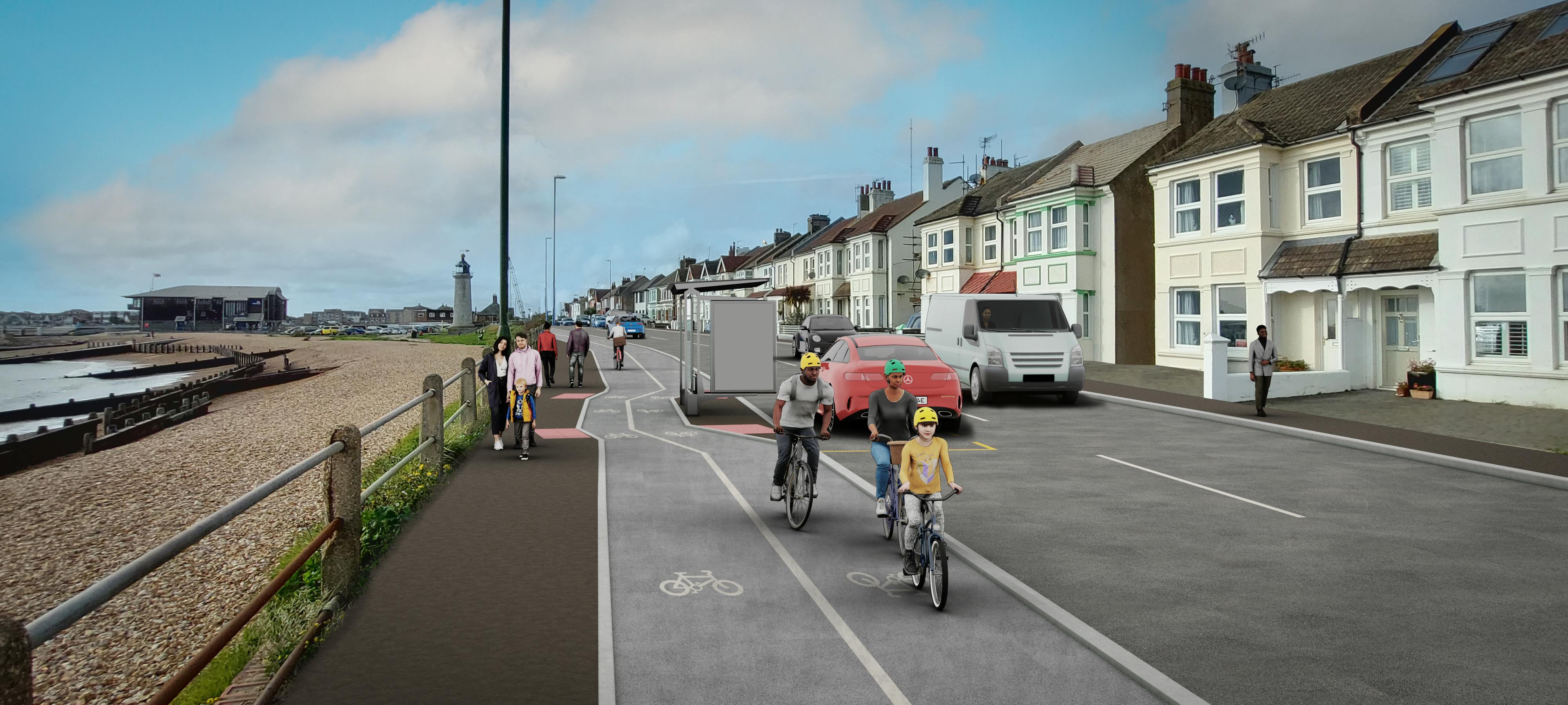
The proposed scheme consists of a mostly two-way cycle lane, separated from the road and footway, on the southern side of the A259, between the junction of East Street and the Adur Ferry Bridge in the west, to the Brighton & Hove boundary in the east. However, there are a number of pinch points along the route that prevent us from being able to provide this high standard of provision along the entire corridor. This means that where we are limited on space, we have instead proposed a ‘shared use’ footway and cycleway to maintain connectivity for cyclists off the road.
Please see the accompanying route maps in the side panel for more information.
The proposed scheme design includes the following features:
- Connections to new or existing additional ‘shared use’ footway and cycleways on the northern side of the A259, at the Eastern Avenue junction to connect with Ham Road, at the Kingston Lane junction, between the junctions with Grange Road and Station Road, as well as between the junctions with The Gardens and Gardner Road. This would improve access for pedestrians and cyclists to Shoreham-by-Sea, Southwick and Fishersgate train stations, as well as the surrounding residential areas, school and colleges.
- Shared cyclist and pedestrian crossings along some side road junctions to reinforce the priority of walkers and cyclists.
- ‘Floating’ bus stops with space for cyclists to pass behind the bus stops to prevent them having to join the road or share the footway with pedestrians.
- Relocating and improving some bus stops to accommodate the proposals and provide additional facilities such as bus shelters and additional real-time passenger information.
- Increasing the width of footways at some junctions to reduce the crossing distance for pedestrians and cyclists.
- Opportunity for streetscape improvements, including planting, to improve the local environment, making it an attractive route to walk and cycle.
- Cycle-only signal phases at some junctions.
- Removing some right turn lanes at junctions to accommodate the new cycle facilities. This includes at the A259 junctions with Victoria Road/Shoreham Terminal access road, and Mill Road.
- Possible removal of approximately seven parking spaces on the northern side of the A259, near to Shoreham Lighthouse, to accommodate cycle facilities at this constrained location.
- HGV access coloured surfacing, signage, and road markings to draw attention to the crossing and cyclist right of way across Shoreham Terminal access road.
- Accommodating verge parking between the junctions of Colebrook Road and The Gardens using ‘Grasscrete’, a reinforced surface covered with grass.
- Reducing the approach to The Gardens junction in the eastbound direction to one lane.
All road users will be considered in the scheme design by maintaining existing on-street parking and highway capacity, where possible, as well as ensuring the new provision for cyclists is of a high quality.
Most of the designs utilise existing highway land, however there are elements of the proposals that would require some land take from private landowners or land that is allocated for redevelopment. We are in dialogue with the impacted landowners to develop these aspects of the proposals.
The proposed scheme will be subject to traffic assessments to determine their impact on the capacity of the A259 and surrounding roads at the next stage of the design process.
Have your say
We are holding two drop-in events so that you can view our proposals and speak to members of the project team:
- Wednesday 1 February: Main School Hall in Swiss Gardens Primary School, Swiss Gardens, Shoreham-by-Sea, BN43 5WH, from 4:30 p.m. to 8:00 p.m.
An education strike is planned to take place on Wednesday 1 February. While Swiss Gardens Primary School will be closed to pupils that day, we can confirm that our evening drop-in event will take place as planned at the school between 4:30-8:00 p.m.
- Monday 6 February: Porter Room in the Southwick Community Centre, 24 Southwick Street, Brighton, BN42 4TE, from 4:00 p.m. to 8:00 p.m.
We are also holding two events for the Lancing & Sompting scheme:
- Wednesday 15 February: Main Atrium at Sir Robert Woodard Academy, Upper Boundstone Lane, Sompting, Lancing, BN15 9QZ, from 4:00 p.m. to 8:00 p.m. The atrium can be accessed via the main reception.
- Wednesday 22 February: an online event, hosted on Microsoft Teams, from 7:00 p.m. to 8:00 p.m. (please register by emailing email us at STIPActivetravel@westsussex.gov.uk)
We would love to hear what you think about our proposals for the A259 between Shoreham and Brighton & Hove, so please tell us your views by completing the survey below the Accessibility Statement and survey web browser compatibility sections.
Next steps
Following the close of the consultation, your responses will be gathered and analysed before being incorporated into a consultation report. This will help us in deciding what amendments may be needed to the designs and the next steps for the scheme, including building the case for funding the schemes.
Accessibility statement
If you require any of the information for this project in an alternative format, please contact us on 01243 642105 or via email at STIPActivetravel@westsussex.gov.uk and we will do our best to assist you. If you are deaf or hard of hearing and have an Next Generation Text (NGT) texting app installed on your computer, laptop or smartphone, you can contact us on 18001 01243 642105 .
We are committed to making this website accessible, in accordance with the Public Sector Bodies (Websites and Mobile Applications) (No. 2) Accessibility Regulations 2018. Please view the West Sussex County Council Accessibility Statement (opens in new window) for further details. Information about the accessibility of the Your Voice Engagement Hub can be found by clicking on the 'Accessibility tab' which can be found right at the bottom of this page.
Where it exists, we will provide details of any project related content which is not fully accessible under a heading of 'Non-accessible content' below.
We are always looking to improve the accessibility of this website. If you find any problems not listed on this page or you think we are not meeting accessibility requirements, then please contact us on 0330 222 2146 or at haveyoursay@westussex.gov.uk
Non-accessible content:
Artist impression - An artist impression of the proposals along the A259 to show how the scheme may look once it is constructed. Additional text has been provided within the webpage to aid understanding.
Route maps - One overview map of the entire scheme along the A259 between Shoreham and the Brighton & Hove boundary complimented by three more detailed maps of the route broken into sections. Additional text has been provided within the webpage to aid the understanding of these maps.
Technical drawings - A more detailed version of the route maps. Additional text has been provided within the webpage to aid understanding.
Survey web browser compatibility
Please use one of the browsers below when completing the survey to ensure it looks and works as it should. These are:
- Microsoft Edge version 86 and above
- Chrome version 86 and above
- Firefox version 78 and above
- Safari version 14 and above