Sep. 21, 2020 – NASA Finds Tropical Storm Dolphin Going Swimmingly
NASA’s Terra satellite obtained visible imagery of recently formed Tropical Depression 14W as it strengthened into a tropical storm. Terra satellite imagery showed the storm was organizing.
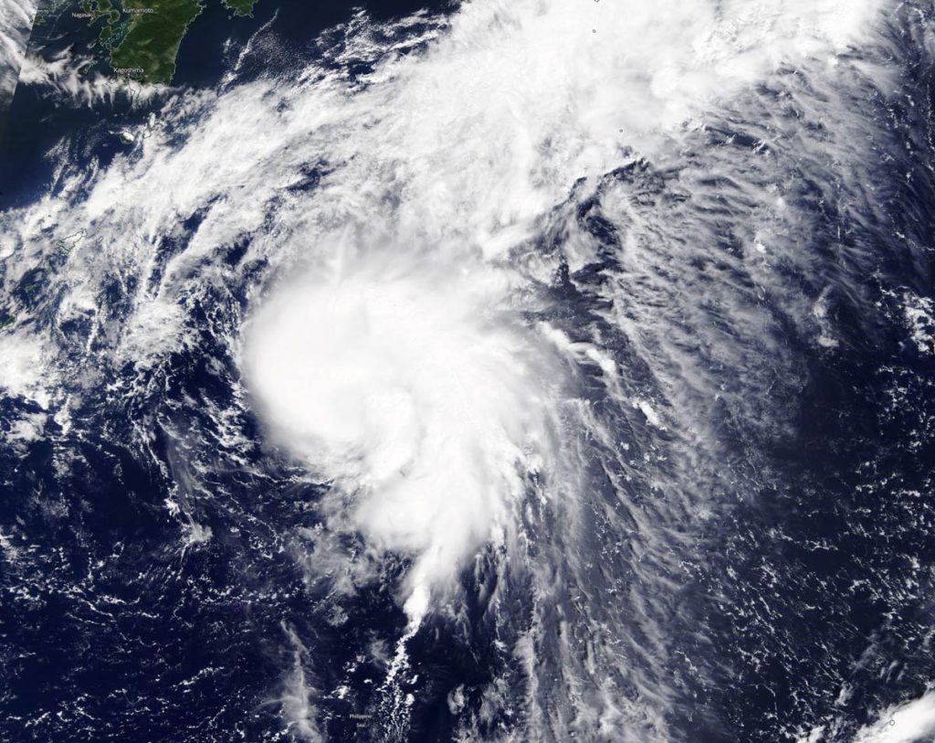
Dolphin developed from Tropical Depression 14W. 14W formed on Sept. 20 about 366 miles east-southeast of Kadena Air Base, Okinawa Island, Japan. By 5 a.m. EDT (0900 UTC) on Sept. 21, the storm organized and strengthened into a tropical storm.
NASA Satellite View: Dolphin’s Organization
The Moderate Resolution Imaging Spectroradiometer or MODIS instrument that flies aboard NASA’s Terra satellite captured a visible image of Tropical Storm Dolphin on Sept. 21. Satellite imagery revealed a persistent deep convection and development of thunderstorms wrapping into a low-level circulation center. That is an indication of consolidation and better organization.
The satellite image was created using NASA’s Worldview product at NASA’s Goddard Space Flight Center in Greenbelt, Md.
Tropical Storm Dolphin on Sept. 21
Tropical storm Dolphin was located about 625 nautical miles south-southwest of Yokosuka, Japan, near latitude 25.7 degrees north and longitude 135.0 degrees east. It was moving slowly to the north-northeast at 4 knots and had maximum sustained winds 45 knots (52 mph/83 kph).
Dolphin’s Forecast and Track
The Joint Typhoon Warning Center (JTWC) forecasts that Dolphin will move north. Then later it is expect to turn to the northeast and strengthen to 55 knots.
JTWC forecasters expect the system to take on additional subtropical characteristics as it moves into an area of decreasing sea surface temperatures and increasing vertical wind shear. The storm’s upper level outflow is also expected to become more strongly associated with the robust westerly wind flow associated with the jet stream. By 11 a.m. EDT (1500 UTC) on Sept. 22, the system will begin extratropical transition and will complete that transition to the south of Japan.
About NASA’s Worldview and Terra Satellite
NASA’s Earth Observing System Data and Information System (EOSDIS) Worldview application provides the capability to interactively browse over 700 global, full-resolution satellite imagery layers and then download the underlying data. Many of the available imagery layers are updated within three hours of observation, essentially showing the entire Earth as it looks “right now.”
NASA’s Terra satellite is one in a fleet of NASA satellites that provide data for hurricane research.
Tropical cyclones/hurricanes are the most powerful weather events on Earth. NASA’s expertise in space and scientific exploration contributes to essential services provided to the American people by other federal agencies, such as hurricane weather forecasting.