Test Deployments Underway for Pioneer Relocation
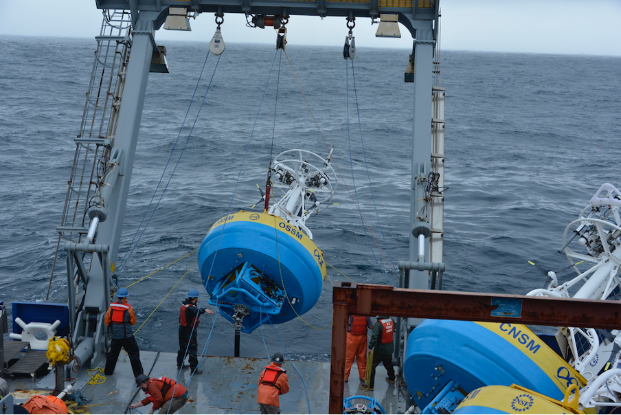
Tuesday February 21, 2023, a team of scientists and engineers from Woods Hole Oceanographic Institution (WHOI) left Charleston, SC aboard the R/V Neil Armstrong to begin test deployments in preparation for the installation of an Ocean Observatories Initiative (OOI) ocean observing system in its new location in the southern Mid-Atlantic Bight (MAB). The science team will deploy two test moorings off the coast of North Carolina, occupying shallow and deep sites of the proposed array. The deployments will supplement computer modeling to ensure the mooring designs perform as expected in the MAB environment. Once the array is fully operational in 2024, the ocean data collected will be available online in near real-time to anyone with an Internet connection.
Ocean observing data helps to track, predict, manage, and adapt to changes in the marine environment. Coastal communities use ocean observing data to prepare for floods and other natural disasters. The instrumented arrays gather physical, chemical, geological, and biological data from the air-sea interface to the seafloor, providing a wealth of information for research and education.
“This new Pioneer Array location in the MAB offers many opportunities for scientists to obtain data to further their research, and will provide better insight into conditions in the area for a variety of stakeholders,“ said Al Plueddemann, Project Scientist for OOI’s Coastal and Global Scale Nodes group at WHOI, which is responsible for operation of the Pioneer Array. “We welcome researchers, educators, and industry members to reach out to us to explore ways we might work together to maximize the usefulness of the data.”
The OOI is funded by the National Science Foundation (NSF) to collect and deliver ocean data in select locations for 25 years or more. This longevity of data collection makes it possible for researchers to identify both short term processes and long-term trends in our changing ocean. The OOI’s Coastal Pioneer Array was designed to be relocatable, and its first deployment was off the coast of New England at the Continental Shelf/Slope interface, where it collected data from 2016 until it was recovered in September 2022. The new location off the coast of North Carolina was chosen by NSF based on input from the science community during a series of NSF-sponsored workshops in 2022.
Dr. Reide Corbett, Executive Director of the Eastern Carolina University’s Coastal Studies Institute (CSI), is enthusiastic about the opportunities the Pioneer Array will bring to the region. “The cross-shelf suite of instrumentation off northeastern North Carolina’s coast is in a region of complex physics and critical ecosystem dynamics that draws interest from many disciplines and creates opportunities for transformational science. This is also in a region with a growing renewable energy sector, including two active offshore wind leases, with opportunities to partner with the agencies involved. The Coastal Studies Institute is excited about the observations that will be made from these instruments, allowing us to better address climate change influences in the coastal ocean, and improve ocean/weather/storm forecasts through data sharing. Beyond just the instruments in the water, the new partnerships and collaborations created as part of this deployment will provide the ability to better engage this socio-economically diverse region, with disadvantaged groups more impacted by sea level rise and climate change compared to many coastal regions. This broad network of partnerships across the region will provide a mechanism to drive knowledge to action,” states Corbett.
The new MAB site represents a different environment than the New England Shelf location and offers opportunities to collect data on a variety of cross-disciplinary science topics, including cross-shelf exchange and Gulf Stream influences, land-sea interactions associated with large estuarine systems, a highly productive ecosystem with major fisheries, processes driving biogeochemical cycling and transport, and fresh-water outflows during extreme rain events.
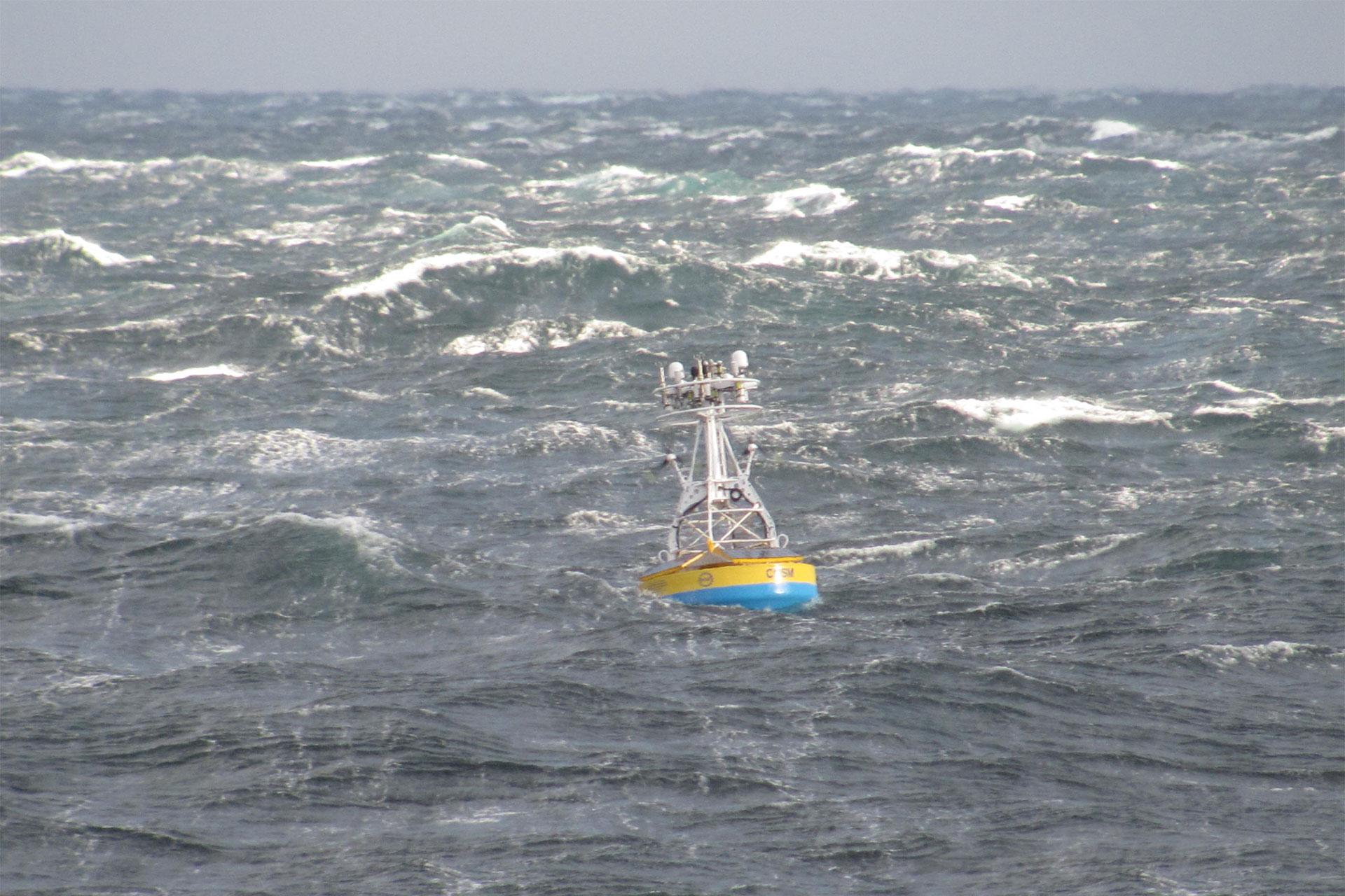
The MAB location is expected to have different wind, wave, and current conditions than the Pioneer Array experienced on the New England Shelf. In addition, deployments in the new location will be in both shallower and deeper water depths than those off the New England coast.
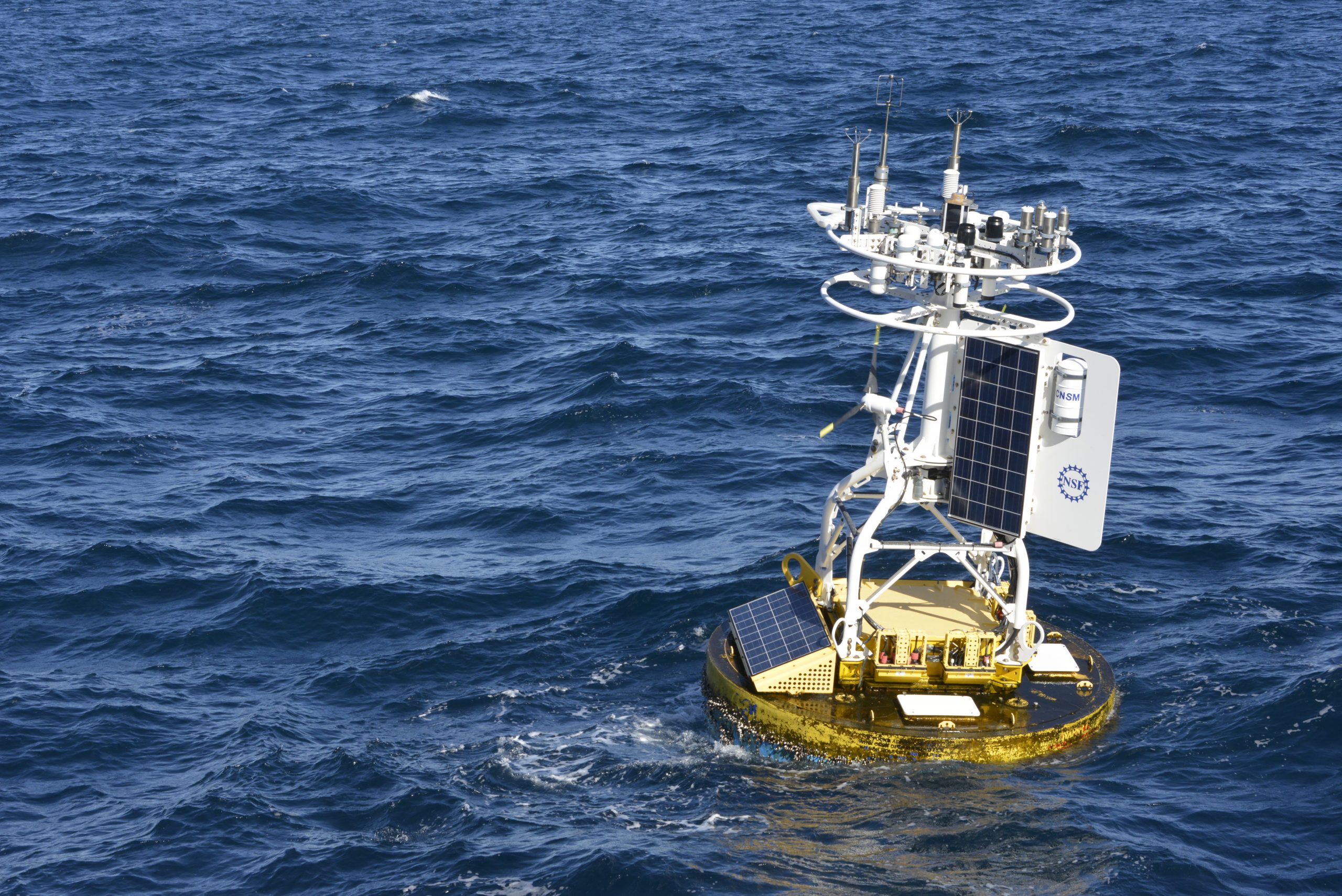
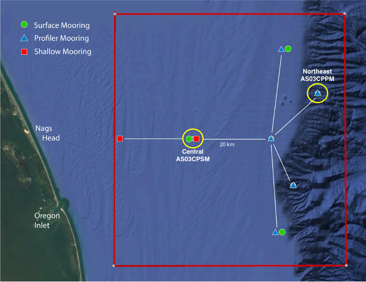
A Coastal Surface Mooring (CSM) will be deployed at 30 meters depth at 35o 57.00’ N, 75o 07.5’ W. The CSM is specifically designed to examine coastal-scale phenomena and withstand the challenging conditions of shallow coastal environments. The Surface Mooring contains instruments attached to a Surface Buoy floating on the sea surface, a Near Surface Instrument Frame 7 meters below the surface, and a Seafloor Multi-Function Node (MFN) located on the seafloor. Additionally, the Surface Buoy contains wind turbines and solar panels for power generation and antennas to transmit data to shore via satellite.
A Coastal Profiler Mooring (CPM) will be deployed at 600 meters depth, 36o 03.80’ N, 74o 44.56’ W. The CPM contains a Wire-Following Profiler that houses instruments. The Wire-Following Profiler moves through the water column along the mooring riser, continuously sampling ocean characteristics from about 23 m below the surface to 23 m above the sea floor. The CPMs also carry an upward-looking Acoustic Doppler Current Profiler to measure ocean currents over the same region of the water column traversed by the profiler.
The test mooring data will be evaluated during the deployment and after recovery to determine whether any modifications are needed to the mooring designs. The plan is to deploy the full array in the spring 2024.
An update on the Pioneer Array relocation is planned for April 20 at 6 pm at the Coastal Studies Institute on East Carolina University’s Outer Banks Campus. Contributing to the CSI “Science on the Sound” lecture series, WHOI’s Dr. Plueddemann will discuss the Pioneer Array infrastructure, instrumentation, and what is planned for its upcoming move off the North Carolina coast. The event is free and open to the public. For those unable to attend, the program will be live-streamed, as well as archived for later viewing, on the CSI YouTube Channel.