


-
TS Arthur tracks along the Gulf Stream
Posted on May 19th, 2020 No commentsBelow is the view of Tropical Storm Arthur in the MARACOOS OceansMap. https://oceansmap.maracoos.org/
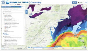
The track of Arthur follows the warm water of the Gulf Stream observed in the satellite SST. Arthur is forecast to now turn more towards the south. Arthur tracked close to 2 gliders that were flying in the Gulf Stream, Silbo operated by TWR and a spray glider operated by WHOI. Silbo in black is shown leaving the Gulf Stream to the north while the Spray glider in gray continues west with the Stream. Currents from the MARACOOS HF Radar network on the Mid Atlantic shelf are strong and alongshore towards the south.

A quick look at the global model temperature profiles as Glider Silbo leaves the Gulf Stream looks like a much faster departure in the models than in the real world. We’ll look more at the slope sea comparison when the glider is out of the Stream in both the model and real world conditions. Plots from all the gliders can be viewed at https://rucool.marine.rutgers.edu/hurricane/Hurricane_season_2020/
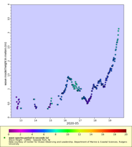
NHC warnings included heavy surf along the Mid Atlantic coast from Arthur. Some of the HF Radar systems in the Mid Atlantic are set up to monitor waves in real time and send the data to the NWS forecast offices. Above is one example of HF Radar derived waves along the NJ coast at Seaside Park, the first site to break 3 m. Waves from the NDBC sites further offshore are approaching 9 ft. The full HF Radar waves dataset can be accessed at
https://marine.rutgers.edu/~hroarty/maracoos/ERDDAP_MAB_HFR_Wave_Data_v2.html
Last 5 posts by Scott Glenn
- Early Season in the Mid Atlantic - June 17th, 2021
- Disturbance in the Gulf - June 16th, 2021
- Hurricane Gliders 2021 - May 3rd, 2021
- Hurricane Iota - November 16th, 2020
- Hurricane Eta - Low Wind Shear, High SST - November 2nd, 2020
