SECOORA is honored to announce the winners of the Request for Proposals to Fill Regional Product and Observational Gaps.
SECOORA received many innovative submissions for this 1-year funding opportunity and three proposals will be funded. One project will conduct environmental and fisheries monitoring with an autonomous underwater vehicle in two Marine Protected Areas and another project will add five new water level sensors along the North Carolina Outer Banks. The third project will focus on the development of machine learning algorithms to create a new navigational product for managing large-vessel traffic at two Florida ports.
Learn more about the funded projects:
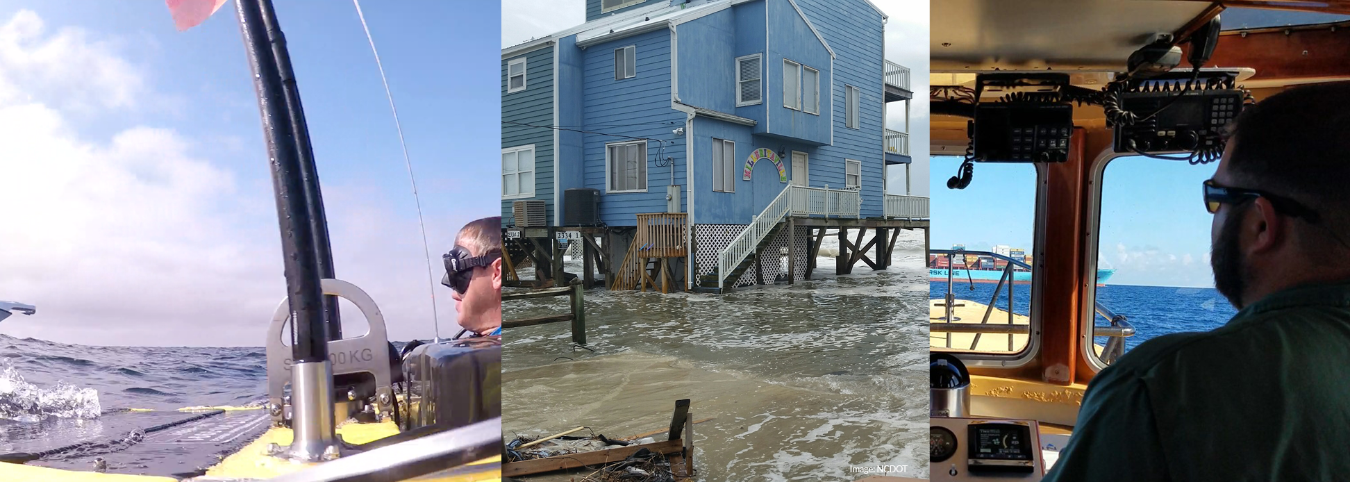
Use of an autonomous underwater vehicle (AUV) for cost-effective assessment of fish utilization of areas of ecological and management importance in US South Atlantic waters
“We are using an advanced autonomous platform to conduct fisheries independent surveys in areas that have been poorly surveyed. We hope to shed some light on the presence of species within the Marine Protected Areas. We are thrilled to be part of the SECOORA mission and we look forward to working with SECOORA’s stakeholders.”
Project Abstract
Mature adults of many fish species swim long distances to gather in high densities for mass spawning at precise locations and times. The South Atlantic Fishery Management Council created Marine Protected Areas (MPAs) and Special Management Zones to protect breeding hotspots and aid in the recovery of overfished species within the snapper grouper complex. However, there is limited fish stock sampling within some of the MPAs and Special Management Zones due to their inaccessible environments. This project will address environmental and fishery sampling needs within two MPAs: St. Lucie Hump and the Oculina Experimental Closed Area, both located off of the East coast of Florida.
The goal of this project is to survey both MPAs with a REMUS 100 unmanned underwater vehicle. The REMUS 100 is equipped with an Acoustic Doppler Current Profiler, a side scan sonar, and a multidirectional camera system. The project team, led by Dr. Laurent Cherubin from Florida Atlantic University alongside co-investigators Drs. Matthew Ajemian, Florida Atlantic University, and Chip Collier, South Atlantic Fisheries Management Council, will evaluate the camera and sonar data after each mission to estimate the presence and abundance of spawning species including gag grouper, scamp, red snapper, hogfish, and gray triggerfish.
The project will demonstrate the utility of a multi-sensor unmanned platform to generate critical data for the management of MPAs while also providing stakeholders with the information they need to evaluate the areas as fish spawning sites.
Northeast North Carolina Coastal Communities Water Level Observation and Prediction System
“Local communities are constantly faced with flooding challenges related to sea level rise. The new water level sensors along the northern North Carolina Outer Banks will help coastal community managers plan for and better manage nuisance flooding to mitigate related expenses.”
Project Abstract
Drs. Michael Muglia, East Carolina University – Coastal Studies Institute, and Nicole Elko, American Shore and Beach Preservation Association, will lead a team to install affordable real-time Hohonu water-level sensors in 5 locations in the North Carolina Outer Bank. The sensors will wirelessly telemeter real-time water level data to make tidal predictions. The project will engage local managers to ensure the execution and outcomes fit the needs of northeastern North Carolina community planners and managers.
The project’s primary goal is to help coastal managers plan for, manage, and adapt to community flooding by providing easy access to water level data. The secondary goal is to provide water level observations to the scientific community to enhance regional sea level rise predictions in northeastern North Carolina. These observations will fill significant data gaps along the Outer Banks and improve tidal and flood modeling efforts. The team is working closely with community stakeholders from Southern Shores, Nags Head, the NC Aquarium’s Jennette’s Pier, and Dare County Emergency Management to find the most impactful sites for the sensors.
Improving the Maritime Traffic Management in Southeast US Waters Using Machine Learning

“We will use Machine Learning algorithms to transform existing ocean observations and model forecasts made by SECOORA and partners into a new decision-support tool to better manage large-vessel traffic in and out of the two busiest ports in the southeast US— Port Miami, FL and Port Everglades, FL. The decision support tool will predict optimal transit windows for vessels to avoid hazardous cross-current conditions 24 to 48 hours in advance, reducing risk associated with vessel passages under high cross-current conditions.”
Project Abstract
Major ocean currents near Florida seaports can generate hazardous cross-flows capable of reducing steerage on large ships and sweeping them into shallow waters, other vessels, or nearby structures. Seaport area collisions threaten ships and cargo and endanger crews and passengers. To aid in large-vessel traffic management, Drs. Mark Luther and Steven Meyerss from University of South Florida College of Marine Science will develop a tool that transforms multivariate ocean current data into a new decision-making product for the Port of Miami and Port Everglades – two of the busiest ports in the Southeast.
This project will reduce the risks associated with vessel maneuvering under hazardous conditions by developing machine learning algorithms to predict cross-current conditions up to 24 or 48 hours in advance. The algorithm will use a variety of data sources, including three NOAA current sensors along the Port of Miami channel, the University of Miami’s High Frequency radar system, and publicly available offshore ocean forecast models. The algorithm will operate automatically, updating forecasted currents every few hours to ensure users receive consistent and accurate information.
Related news

New High Frequency Radar at the Dry Tortugas National Park Improves Ocean Surface Current Measurements Across the Straits of Florida
A new CODAR Low-Power SeaSonde HFR has been deployed by the University of South Florida at Fort Jefferson on Garden Key to measure surface currents to improve understanding and prediction of the Gulf of Mexico Loop Current.

President Biden Proposes Significant Budget Cuts to IOOS for 2025
President Biden’s recent 2025 budget proposal slashed the funding allocated for the Integrated Ocean Observing System (IOOS) by 76%, which would effectively shut down coastal and ocean observing efforts.

Webinar: NOAA Resources to Help Coastal Communities Understand Flood Risk
Join us Wednesday, March 27th at 12 PM Eastern Time for SECOORA's Coastal Observing in Your Community Webinar Series to hear from Doug Marcy with the NOAA Office for Coastal Management.