New lakebed mapping tool to assist in collaboration, efficiency

Here is a screenshot of the Digital Atlas application interface for prioritizing mapping areas. The selection grid overlaid on the study area is on the right.
ALPENA — New technology will assist researchers, biologists, geologists, and many more to collaborate in lakebed mapping for more efficiency, saving both time and money for multiple agencies while providing a more detailed look at the underwater world.
NOAA’s National Centers for Coastal Ocean Science (NCCOS) and Thunder Bay National Marine Sanctuary (TBNMS) recently completed a mapping prioritization study that will help guide future lakebed mapping, research, and exploration efforts in sanctuary waters in Lake Huron. The study gathered the most urgent mapping needs from 24 local experts in order to identify common mapping priorities and better understand the resources of the sanctuary, a news release explains.
“To take it and be able to put it in a digital tool that anybody can use, it really can increase our efficiency and our collaboration opportunities to go out and get this data collection done,” TBNMS Maritime Archaeologist Stephanie Gandulla said. “Which is important, because we’ve only mapped a very small percentage of the Great Lakes.”
“TBNMS encompasses 4,300 square miles of Lake Huron off the northeastern shore of Michigan, and is home to many culturally important shipwrecks. However, a large area of the sanctuary remains unmapped. Approximately 16% of the lakebed within the sanctuary has been surveyed, and much of the mapping was completed prior to 1950 when techniques were more primitive,” the release notes.
Gandulla noted that only about 4% of the Great Lakes as a whole have been mapped, but that 16% of sanctuary waters have been mapped.

Courtesy Photos Above, A sanctuary archaeologist explores the wreck of the wooden steam barge Shamrock, lost in Thunder Bay in 1905. Credit: Jennifer Idol.
“So we’re ahead of the curve,” Gandulla said. “But as far as the Great Lakes, there’s much that is not mapped with the latest technologies. It’s kind of an unknown, kind of like the ocean. It’s the next frontier. There’s a lot to discover out there yet, and not just shipwrecks.”
The study, called “Priorities for Lakebed Mapping in Lake Huron’s Thunder Bay National Marine Sanctuary,” was authored by Gandulla, Matthew S. Kendall, Ken Buja, Charles Menza, and Bethany Williams.
Kendall, a marine biologist with NOAA’s NCCOS, spoke on the phone on Friday from Silver Spring, Maryland, where NOAA headquarters are located.
“This is a tool that we’ve used in a bunch of different places now, and it’s all about improving efficiency of mapping activities,” Kendall said. “So, in the case of the Thunder Bay sanctuary, right, it’s this huge area, it’s this vast part of Lake Huron, and they’ve only actually mapped 16% of the bottom has been mapped with good, modern techniques. So that’s a really huge area that they haven’t yet taken a good look at from a mapping perspective.”
“Updated lakebed maps are needed to better detect, characterize, and monitor submerged resources and ecologically important areas within TBNMS,” the release explains. “Modern mapping technologies can not only locate new shipwreck sites, but also provide more accurate and resolved depths, and also characterize the substrate types of the lakebed.”
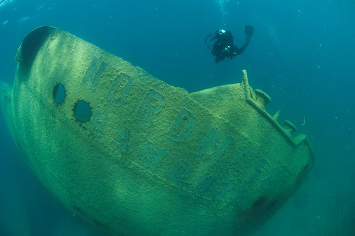
The 500-feet long freighter Nordmeer, sunk in 1966, is an ideal shallow snorkel and dive site. Credit: NOAA, Thunder Bay National Marine Sanctuary.
However, the sanctuary is vast and the entire area cannot be mapped in a short time frame. To identify the various mapping needs within TBNMS, NCCOS developed a digital atlas to efficiently gather input on mapping priorities from multiple stakeholders. Researchers invited a diverse array of respondents to participate in the effort, including archaeologists, biologists, coastal and fisheries managers, and other groups. The common thread among all respondents was that they relied heavily on lakebed maps within the sanctuary as a key input to their research or management decisions.
Using the application, each respondent was given 200 virtual coins to place anywhere within the project area that they felt was a priority for future mapping, and convey their recommendations what types of map data are needed, when the products are needed, and to justify why the site is a priority for mapping. The system then standardized inputs using a geographic information system (GIS) framework, enabling researchers to identify shared mapping interests.
“It makes it so all these different researchers don’t have to go it alone,” Kendall said. “They can now identify potential partnerships and really save a lot of money and get a lot more done.”
The results from this prioritization effort will be used by researchers and managers to identify collaborative opportunities in locations where their interests overlap, and improve the efficiency of future mapping projects in the sanctuary. This report and prioritization effort were part of a larger NCCOS-funded project to support mapping in Lake Huron’s Thunder Bay National Marine Sanctuary.
A webinar called “Lakebed 2030: Early Contributions in Thunder Bay National Marine Sanctuary” will be held at 3:30 p.m. today, hosted by Gandulla, Lindsay Gee of Ocean Exploration Trust, Val Schmidt of the University of New Hampshire, and Linden Brinks of the Great Lakes Observing System. The webinar will provide more details on the importance of collaboration in lakebed mapping to map all the Great Lakes by 2030.
To register for the webinar, which will be recorded and available to watch at a later date, visit lakebed2030.org.
-

- Here is a screenshot of the Digital Atlas application interface for prioritizing mapping areas. The selection grid overlaid on the study area is on the right.
-

- Courtesy Photos Above, A sanctuary archaeologist explores the wreck of the wooden steam barge Shamrock, lost in Thunder Bay in 1905. Credit: Jennifer Idol.
-

- The 500-feet long freighter Nordmeer, sunk in 1966, is an ideal shallow snorkel and dive site. Credit: NOAA, Thunder Bay National Marine Sanctuary.
Lifestyles

RCCT presents ‘Something Rotten!’ opening Friday in R.C.
Walking away is standing up for yourself
Growth is incredibly uncomfortable, and so worth the effort. If you’ve been reading my columns, over time ...
SUNRISE SIDE BULLETIN BOARD
Spring Tree Sale going on now; Friday deadline ALPENA — Alpena-Montmorency Conservation District’s Spring Tree ...

Pinwheels planted for Child Abuse Prevention Month

National Day of Prayer Breakfast May 2
